
Wednesday, December 13, 2006
Building a GIS Program in Middle School
Recently I have had online conversations with some fine folks around the world, literally, regarding the use of GIS within a middle school. A few years ago I wrote an article for the SITE conference that gives my experience with building a program in a middle school. I started as the only person on campus with GIS experience...so it's possible to start small and grow.Here is a link to a *.pdf of my article: http://members.cox.net/baduke/BuildGISProgMS.pdf If you have any questions or need materials, I'm happy to share what I have.
Tuesday, November 14, 2006
Get out in the geography!
As many educators know, experiencing the landscape in person brings to life the maps, data and curriculum that we are giving students. A great way to experience the globe is to visit a confluence. Yes, that's confluence not conference. What is a confluence? It's the intersections of latitude and longitude all over the globe. There's a group of globe trekkers that make it their mission to visit as many of these intersections/confluences as possible. My good friend and collegue, Dr. Joseph Kerski, is one such adventurer. I joined him this fall while we were in Lake Tahoe. You can read about our journey at http://www.confluence.org/confluence.php?visitid=12953. You can get more about the Confluence Project at http://www.confluence.org .
Happy GIS Day 2006!
GIS Day is upon us tomorrow November 15th. This day coincides with National Geography Awareness Week. For all the educators our there, the resources are bountiful.
Some great ones are listed here:
ESRI
http://www.esri.com/industries/k-12/education/gaw.html
Google
http://www.google.com/educators/gaw.html
National Geographic's Mapmachine
http://plasma.nationalgeographic.com/mapmachine/index.html
My Wonderful World (.org)
http://www9.nationalgeographic.com/mywonderfulworld/docs/
Some great ones are listed here:
ESRI
http://www.esri.com/industries/k-12/education/gaw.html
http://www.google.com/educators/gaw.html
National Geographic's Mapmachine
http://plasma.nationalgeographic.com/mapmachine/index.html
My Wonderful World (.org)
http://www9.nationalgeographic.com/mywonderfulworld/docs/
Tuesday, October 24, 2006
Teacher Resources-Text Mapping, Google Educators
Text Mapping Project-another excellent tool for literacy
http://www.textmapping.org/overview.html
Google for Educators
http://www.google.com/educators/index.html
http://www.textmapping.org/overview.html
Google for Educators
http://www.google.com/educators/index.html
Sunday, October 08, 2006
NCGE Conference Day 3
Last day of the conference ends on a high note. I attended the Literacy Task Force discussion. This group of dedicated geography/literacy teachers is moving forward to further awareness and integration of literacy elements in other curricular areas. As a former English Language Arts teacher myself, I'm excited about being involved with this part of NCGE.
Then, I went to Dr. Joseph Kerski's session on utilizing Topographic maps and GPS. We even took a tiny field trip to use those GPS units! Joseph offers great ideas and expertise. After many years with USGS, he is now working with ESRI. He is a great asset in the geographic education field and offers generous support for educators. http://www.josephkerski.com Just ask!
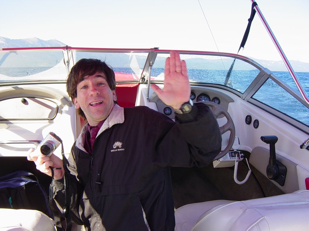
Following Joseph's session, he and I got a boat and ventured to the nearby confluence, 39N 120W. Joseph has many confluences under his belt, over 100. This journey was my first confluence. You can read about Joseph's adventures along with other globe trotters at http://www.confluence.org .
Then, I went to Dr. Joseph Kerski's session on utilizing Topographic maps and GPS. We even took a tiny field trip to use those GPS units! Joseph offers great ideas and expertise. After many years with USGS, he is now working with ESRI. He is a great asset in the geographic education field and offers generous support for educators. http://www.josephkerski.com Just ask!
Following Joseph's session, he and I got a boat and ventured to the nearby confluence, 39N 120W. Joseph has many confluences under his belt, over 100. This journey was my first confluence. You can read about Joseph's adventures along with other globe trotters at http://www.confluence.org .
Saturday, October 07, 2006
Amazing Landscapes
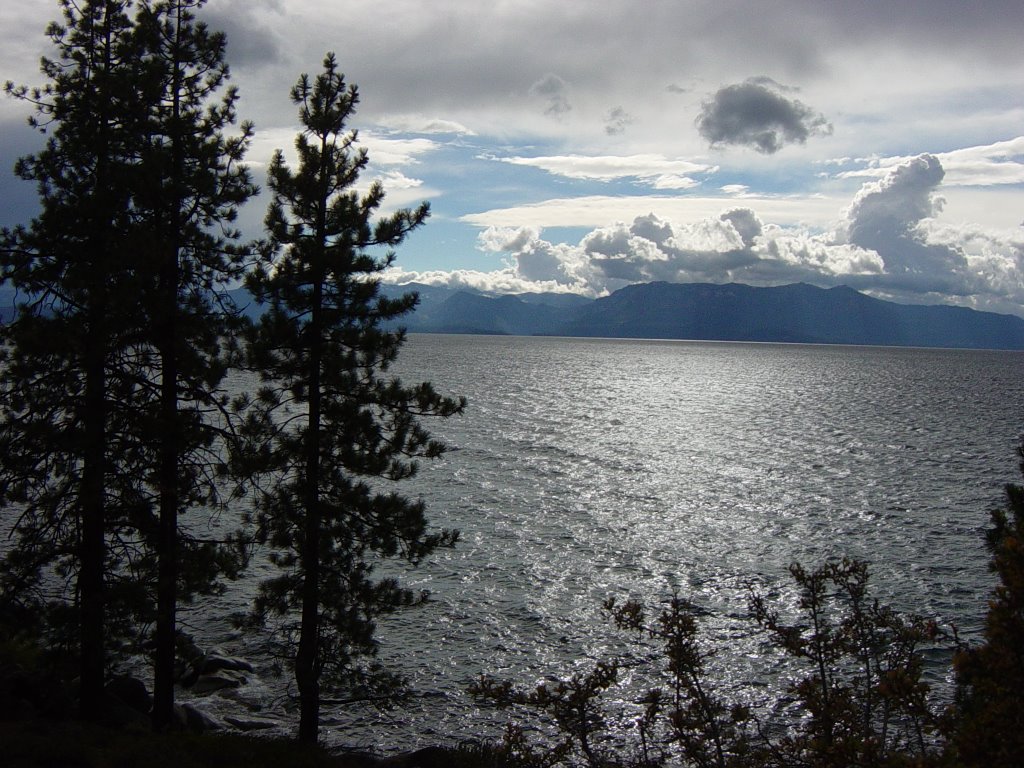
You cannot help being impressed with views like this one. Much like the Grand Canyon in AZ, you can't take a bad picture here.
NCGE Conference Day 2
A special thanks to those folks who attended our session! Shannon and I hope you found it helpful. After seeing Shannon off to her next journey, the UK...I headed off to an ESRI session. Ann Johnson did a great job showing us how to use ArcGlobe, Spatial Analyst and ArcScene to give a 3D view of earthquake depth. After creating the depth 3D view you can create an animation.
While we're in this beautiful location, I took the lunch hour time to go to the top of Heavenly...the nearby ski slopes. The Gondola ride takes you to the top of the mountain for an amazing view. It's worth taking the time to see this beautiful landscape from that vantage point.
Lots of great sessions to see! More later!
NCGE Day 1, P.S.
One more thought...you just gotta checkout the latest from our friends at ESRI...ArcWeb Explorer! Zowie it's cool!
http://www.arcwebservices.com/awx/index.jsp
http://www.arcwebservices.com/awx/index.jsp
NCGE Conference Day 1

WOWZA! If you are an educator, then this conference is for YOU! The sharing of ideas is the number one focus of this group of dedicated folks...sure they love geography, but there's geography in everything, RIGHT!
After last night's reception, where I met some fantastic folks, today brought sessions and exhibits a plenty. My conference journey started with Marilyn Weiser of Minot, ND. She shared her success with David Smith's book If the World Were A Village. Her students explored the concepts of the book and then applied those to their village, North Dakota. The students produced books of their findings...very cool stuff for kids. There were thinking and they never knew it hit them! The implications here for global understanding, math concepts and so much more are easy to see. Check out David's web site at http://www.mapping.com for more information on his books and materials.
Following Marilyn's presentation, Sister Madeleine Gregg from the University of Alabama shared her experiences with the primary classroom and poetry. Sister Madeliene is a dynamic speaker and just plain fun! Her intriguing account of "sneaking" geography into poetry and reading is so fantastic. With the focus on literacy, she utilized poetry to teach phonetic awareness, vocabulary, fluency and comprehension to her 3rd graders. She says, "By choosing poetry with strong geography content, teachers can create more time for geography in their curriculum." Being a former English Language Arts teacher myself, I identify with her "sneaky" use of geography in of all places, ENGLISH CLASS!
After some lunch and perusing the exhibits, I heard Barbara Soto from Arizona. She presented her methods on getting students aware of human impact on ecosystems. Her geostories were beautifully done and highly effective with the K-5 students in her school.
Shannon and I spent the remainder of the afternoon doing some "field work". You can't come to beautiful landscape like this place and not get out into the nature...and take a photo or two. We had a great time taking in the splendor of nature.
It was a great FRIDAY at the NCGE conference !
Wednesday, September 27, 2006
NCGE Conference 2006
Next week, I'm headed west to Lake Tahoe, NV for the National Council for Geographic Education Conference. I'll relay here my experiences as well as any resources that I find for the GIS in Education community. This conference is a boost in the arm for educators and those who support geographic education. The ideas and research presented enhances our efforts to further GIS and related technologies in education. If you're attending the conference, then say "hello!" You can catch me Saturday morning with Dr. Shannon White, Asst. Director at the Florida Center for Instructional Technology-USF, presenting "Mapping Cross-Curricular Integration."
Sunday, August 27, 2006
GIS Help and Outreach
What other GIS resources are available to me as an educator?
by Shannon H. White, Ph.D.
Courses and other training
- Colleges, universities and community colleges
- Many educational institutions offer courses in GIS. There are few courses designed for educators and integration of GIS in the K-16 setting. Check with your local college, university and community colleges for GIS related courses.
- ESRI Virtual Campus
ESRI has a Virtual Campus (www.campus.esri.com) with discounted online courses for educators. These courses are based upon a variety of ESRI products. They have been developed so that those enrolled can work at their own pace. These are a good place to start for novices and as a review for the more advanced users. - Other Training
There are numerous training opportunities offered by organizations and agencies. The KanGIS website is one location to locate GIS training, workshops, institutes that are upcoming across the nation and world. (http://kangis.org/learning/calendar/) There are also companies such as GISEtc (http://www.GISetc.org) that offer GIS training for schools and communities. ESRI also has a "Friends of GIS Education" list of companies and agencies (http://www.esri.com/industries/k-12/resources/foge.html ). They support GIS education with products, training, and resources.
Books
This is not a complete list but a few of our favorites focused on GIS in Education!
GIS Books For and About Educators- GIS in the Classroom: Using Geographic Information Systems in Social Studies and Environmental Science by Dr. Marsha Alibrandi (2003) Heinemann Press
- GIS in Schools by Richard Audet and Gail Ludwig (2000) ESRI Press
- Mapping Our World: GIS Lessons for Educators by Lyn Malone, Anita Palmer, Christine Voigt (2002) ESRI Press
- Community Geography: GIS in Action by Kim English and Laura Feaster (2003) ESRI Press
- Community Geography: Teachers Guide by Lyn Malone, Anita Palmer, Christine Voigt (2003) ESRI Press
- The Essentials of the Environment by Joseph Kerski and Simon Ross (2005) Hodder Arnold
- A to Z GIS: An Illustrated Dictionary of Geographic Information Systems by Shelly Sommer and Tasha Wade, Editors (2006) ESRI Press
GIS Software Reference books
- Getting to Know ArcView GIS (1997) ESRI Press
- Getting to Know ArcGIS Desktop (2001) ESRI Press
- GIS for Everyone 3rd Edition (2003) ESRI Press
- GPS Reference books
- Fun with GPS by Donald Cooke (2005) ESRI Press
- GPS for Dummies by Joel McNamara (2004) For Dummies Press
- How to Do Everything with your GPS by Rick Broida (2003)
- GPS Mapping by Rich Owings (2005)
Agencies and Organizations
There are numerous local, state, regional, and national agencies and organizations that are helpful to educators. They may come to your school to give a presentation; to help you find data; to donate hardware such as a used plotter, to help answer your GIS questions. GIS partners in your community can help your bring GIS to your students. They bring real life problems, experiences and GIS work to your classroom.Suggestions of GIS partners may include:
In your city, town or county:
- local GIS office
- local police, fire and rescue services
- local utility companies and departments (electric, natural gas, water, sewer, etc)
- tax assessors office or deed office
- city planner
- historic commission
- voter registration
- community colleges, colleges, universities (look for Geography departments or search GIS on their website)
In your State:
- Highway Department or Transit Authorities
- Department of Natural and Environmental Resources
- Regional Planning Commissions
- Historic Commission or Registry
- Spatial Data Clearinghouses
- Geographic Alliances (http://www.ngsednet.org/community/about.cfm?community_id=94 )
National Agencies and Organizations
- US Geologic Survey - http://www.usgs.gov
- Site specifically for educators: http://rockyweb.cr.usgs.gov/outreach/giseduc.html
- US Census Bureau - http://www.census.gov/
- Environmental Protection Agency (EPA) - http://www.epa.gov/
- Federal Emergency and Management Agency (FEMA) - http://www.fema.gov/
- National Aeronautics and Space Administration (NASA) - http://education.nasa.gov/edoffices/centeroffices/index.html )
- National States Geographic Information Centers (http://www.nsgic.org/states/index.cfm )
- Geospatial Information and Technology Associations (GITA) Regional Chapters: http://www.gita.org/chapters/chapters2.html
- Urban and Regional Information Systems Association (URISA) Chapters: http://urisa.org/chapters/chapters.htm
- National Center for Geographic Information and Analysis (http://www.ncgia.ucsb.edu/ )
International Resources
- Geospatial Information and Technology Associations (GITA) Global Affiliates: http://www.gita.org/global_affiliates/global2.html
- Urban and Regional Information Systems Association (URISA) International Chapters: http://urisa.org/chapters/chapters.htm
- GISIG-Geographical Information Systems International Group: http://www.gisig.it/
- UNIGIS (International Universities and Colleges offering courses in GIS) - http://www.unigis.net/
- International Map Trade Association - http://www.maptrade.org/
- In addition, there are libraries that are repositories of GIS data. The NC State University is one such library (http://www.lib.ncsu.edu/stacks/gis/).
Sunday, August 13, 2006
Tuesday, August 08, 2006
Day 4 EdUC: Resources and Ideas
The theme of my Day 4 was without question "Resources and Ideas." Dr. Shannon White presented this morning her continued research on "Sustaining K-12 GIS" by continuing her case study of the Martin Middle School experience. She and I also presented our "Exploring Resources in the K-12 Classroom." We shared the stage with some excellent folks from University of Redlands and Mr. Wadwani from Applied Field Data Systems. We also joined the discussion at the Education Research SIG meeting.
We've had a great conference and are headed back to the east coast to continue making a difference in education, GIS and otherwise.
Everyone can zap us at barbareeduke@gmail.com or shannonhwhite@gmail.com !
We've had a great conference and are headed back to the east coast to continue making a difference in education, GIS and otherwise.
Everyone can zap us at barbareeduke@gmail.com or shannonhwhite@gmail.com !
Sunday, August 06, 2006
ESRI EdUC Day 1 & 2: Computers and Workshops and Sessions, Oh MY!
Day 1: After the opening session, we hit the ground running, I saw a map design lab and an excellent presentation by the folks from Montanta about their project Science Goes Spatial (www.spatialsci.com).
Day 2:
Today was an exciting journey in the computer lab for me! I had the chance to customize buttons, and an opportunity to practice and learn more about ArcMap and ArcIMS! We learned how to take *.jpegs of historical maps and georeference them with current maps. It was just TOO MUCH fun for a map geek!!! If you're interested on the how-to, I'll be happy to share. More on the geek train...I was working on html and java code in the ArcIMS customizing session.
Other than that I was encouraged by the great turnout for the Curriculum Developers SIG. Charlie Fitzpatrick and George Dailey (http://www.esri.com/industries/k-12/news-community/contact.html) led us in an outstanding discussion of:
- What's in place?
- What are you doing?
- What's needed?
Thursday, August 03, 2006
Opening Session ESRI Education Users Conference ~San Diego, CA
What a great opening session! With much more to come, we're inspired and encouraged to make a difference in spatial thinking and geographic awareness.
Here are my high points:
If you have a site license then you might want to check out...
ESRI Software Promotion for GIS Students at Institutions
with a Campus-Wide Site License
http://www.esri.com/slpromo
and
2006 ArcLessons Challenge (it's a contest!)
http://www.esri.com/arclessons
On the research front:
Spatial Thinking report
Learning to Think Spatially
http://www.esri.com/industries/k-12/education/thinking_spatially.html
Check out the new Training website
http://training.esri.com
AND THERE'S MORE...
From American Association of Geographers
AAG publishes GIS& T Body of Knowledge in Collaboration with UCGIS
http://www.aag.org/bok/
Allen Carroll from National Geographic recommends:
My Wonderful World
http://mywonderfulworld.org
Map Machine
http://www.nationalgeographic.com/maps/
Conservation GeoPortal
http://www.conservationmaps.org
Monday, July 31, 2006
Workshops and Presentations
July 2006 ~ NECC, San Diego, CA
"Calling All Explorers: Mapping Your Curriculum with GIS"
August 2006 ~ ESRI Education Users Conference, San Diego, CA
"Exploring Resources" Tuesday, August 8th at 1:30pm
October 2006 ~ NCGE Conference, Lake Tahoe, NV
"Mapping Cross-Curricular Integration" Saturday, October 7th at 10AM
Anytime you're interested in learning more about curricular integration of technology and GIS, please contact me for a specialized workshop to meet your groups' needs at barbareeduke@gmail.com .
Subscribe to:
Posts (Atom)