My hat's off to these creative thinkers. Check out http://www.googlelittrips.com!
While you're playing with Google Earth, be sure to look under featured content for the Rumsey collection. What a cool experience to see these historic maps ON THE GLOBE! By the way, you will need the latest version of Google Earth to utilize this feature. You can view more of David Rumsey's impressive collection at http://www.davidrumsey.com.

Wednesday, March 21, 2007
Friday, March 09, 2007
Great Article
A friend sent this article to me...thought you folks might be interested!
http://www.eschoolnews.com/resources/reports/gis/index.cfm
http://www.eschoolnews.com/resources/reports/gis/index.cfm
Thursday, March 08, 2007
New Website
Greetings again from Alexandria, VA! I've changed my website so now that no matter where I live, the web will be active. You can now reach me at http://www.barbareeduke.com in addition to this blog. I'll be doing my best to keep things updated as I begin new projects.
Thanks for your interest! ~Barbaree
Thanks for your interest! ~Barbaree
Tuesday, February 13, 2007
Driving GIS in Education
Stuck at home on a snowy and icy day...working on my upcoming presentations and lessons...
Question of the day is: What is driving GIS in Education?
Industry perspective?
Curriculum perspective?
Teacher perspective?
Data or curriculum?
Are there other things driving the content that is produced?
What does the community need over what's being done?
Question of the day is: What is driving GIS in Education?
Industry perspective?
Curriculum perspective?
Teacher perspective?
Data or curriculum?
Are there other things driving the content that is produced?
What does the community need over what's being done?
Friday, January 12, 2007
Literature and GIS
Well, I'll be on the road again in February. I'm joining the good folks in Dallas, TX at Bishop Dunne Catholic School for GEOTECH 2007. For those of you interested in integrating GIS and geography with literature and language arts in the K-12 classroom, you'll love this information. Find out more at http://www.bdhs.org/geotech/.
Wednesday, December 13, 2006
Building a GIS Program in Middle School
Recently I have had online conversations with some fine folks around the world, literally, regarding the use of GIS within a middle school. A few years ago I wrote an article for the SITE conference that gives my experience with building a program in a middle school. I started as the only person on campus with GIS experience...so it's possible to start small and grow.Here is a link to a *.pdf of my article: http://members.cox.net/baduke/BuildGISProgMS.pdf If you have any questions or need materials, I'm happy to share what I have.
Tuesday, November 14, 2006
Get out in the geography!
As many educators know, experiencing the landscape in person brings to life the maps, data and curriculum that we are giving students. A great way to experience the globe is to visit a confluence. Yes, that's confluence not conference. What is a confluence? It's the intersections of latitude and longitude all over the globe. There's a group of globe trekkers that make it their mission to visit as many of these intersections/confluences as possible. My good friend and collegue, Dr. Joseph Kerski, is one such adventurer. I joined him this fall while we were in Lake Tahoe. You can read about our journey at http://www.confluence.org/confluence.php?visitid=12953. You can get more about the Confluence Project at http://www.confluence.org .
Happy GIS Day 2006!
GIS Day is upon us tomorrow November 15th. This day coincides with National Geography Awareness Week. For all the educators our there, the resources are bountiful.
Some great ones are listed here:
ESRI
http://www.esri.com/industries/k-12/education/gaw.html
Google
http://www.google.com/educators/gaw.html
National Geographic's Mapmachine
http://plasma.nationalgeographic.com/mapmachine/index.html
My Wonderful World (.org)
http://www9.nationalgeographic.com/mywonderfulworld/docs/
Some great ones are listed here:
ESRI
http://www.esri.com/industries/k-12/education/gaw.html
http://www.google.com/educators/gaw.html
National Geographic's Mapmachine
http://plasma.nationalgeographic.com/mapmachine/index.html
My Wonderful World (.org)
http://www9.nationalgeographic.com/mywonderfulworld/docs/
Tuesday, October 24, 2006
Teacher Resources-Text Mapping, Google Educators
Text Mapping Project-another excellent tool for literacy
http://www.textmapping.org/overview.html
Google for Educators
http://www.google.com/educators/index.html
http://www.textmapping.org/overview.html
Google for Educators
http://www.google.com/educators/index.html
Sunday, October 08, 2006
NCGE Conference Day 3
Last day of the conference ends on a high note. I attended the Literacy Task Force discussion. This group of dedicated geography/literacy teachers is moving forward to further awareness and integration of literacy elements in other curricular areas. As a former English Language Arts teacher myself, I'm excited about being involved with this part of NCGE.
Then, I went to Dr. Joseph Kerski's session on utilizing Topographic maps and GPS. We even took a tiny field trip to use those GPS units! Joseph offers great ideas and expertise. After many years with USGS, he is now working with ESRI. He is a great asset in the geographic education field and offers generous support for educators. http://www.josephkerski.com Just ask!
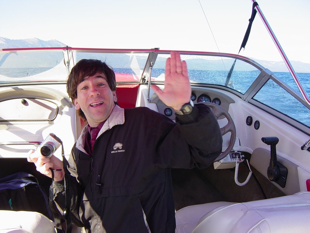
Following Joseph's session, he and I got a boat and ventured to the nearby confluence, 39N 120W. Joseph has many confluences under his belt, over 100. This journey was my first confluence. You can read about Joseph's adventures along with other globe trotters at http://www.confluence.org .
Then, I went to Dr. Joseph Kerski's session on utilizing Topographic maps and GPS. We even took a tiny field trip to use those GPS units! Joseph offers great ideas and expertise. After many years with USGS, he is now working with ESRI. He is a great asset in the geographic education field and offers generous support for educators. http://www.josephkerski.com Just ask!
Following Joseph's session, he and I got a boat and ventured to the nearby confluence, 39N 120W. Joseph has many confluences under his belt, over 100. This journey was my first confluence. You can read about Joseph's adventures along with other globe trotters at http://www.confluence.org .
Saturday, October 07, 2006
Amazing Landscapes
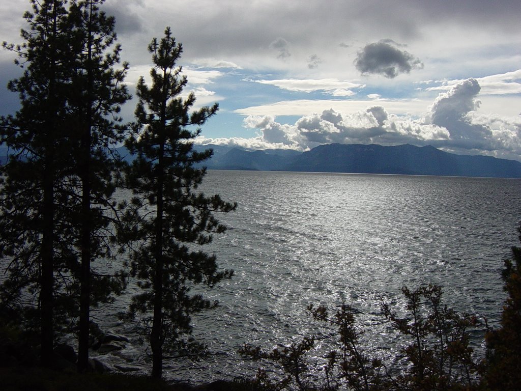
You cannot help being impressed with views like this one. Much like the Grand Canyon in AZ, you can't take a bad picture here.
NCGE Conference Day 2
A special thanks to those folks who attended our session! Shannon and I hope you found it helpful. After seeing Shannon off to her next journey, the UK...I headed off to an ESRI session. Ann Johnson did a great job showing us how to use ArcGlobe, Spatial Analyst and ArcScene to give a 3D view of earthquake depth. After creating the depth 3D view you can create an animation.
While we're in this beautiful location, I took the lunch hour time to go to the top of Heavenly...the nearby ski slopes. The Gondola ride takes you to the top of the mountain for an amazing view. It's worth taking the time to see this beautiful landscape from that vantage point.
Lots of great sessions to see! More later!
Subscribe to:
Posts (Atom)